
Articles
- Page Path
- HOME > GEO DATA > Volume 3(4); 2021 > Article
-
Article
Geology
확장된 지형/수문 분석 데이터 구축 및 서비스 - 이사로*, 김민주
- Construction of Topographic/Hydrologic Data using DEM and its Service 2
- Saro Lee*, Minju Kim
-
GEO DATA 2021;3(4):1-10.
DOI: https://doi.org/10.22761/DJ2021.3.4.001
Published online: December 31, 2021
한국지질자원연구원 플랫폼연구본부 지질자원데이터센터, 대전 34132, 대한민국
Geoscience Platform Research Division, Korea Institute of Geoscience and Mineral Resources (KIGAM), Daejeon 34132, Republic of Korea
- *Corresponding author: leesaro@kigam.re.kr
• Received: September 29, 2021 • Revised: November 1, 2021 • Accepted: November 2, 2021
Copyright © 2021 GeoAI Data Society
This is an Open Access article distributed under the terms of the Creative Commons Attribution Non-Commercial License (http://creativecommons.org/licenses/by-nc/3.0/) which permits unrestricted non-commercial use, distribution, and reproduction in any medium, provided the original work is properly cited.
- 961 Views
- 67 Download
요약문
- 본 연구에서는 수치지형모델(DEM)을 이용하여 기존에 이미 구축된 총 20종의 지형/수분 분석도에 추가로 다양한 지형/수문 분석을 통해 지형 분석도 26종, 수문 분석도 6종 등 총 32종을 추가 구축하였다. 기존의 구축된 데이터와 같이 구축 범위는 남한 전체이며 해상도는 30 m이며 좌표계는 UTM-K 좌표이다. 구축된자료 형태는 ASCII, ARCGIS GRID, GEOTIFF 등 3가지 형태로 남한 통판 자료와 행정구역 별로 제공된다. 이러한 모든 지형/수문 분석 데이터는 환경빅데이터 플랫폼(www.bigdata-environment.kr)에서 무료로 다운로드 가능하다.
Abstract
- In addition to a total of 20 types of topography/moisture analysis maps that have already been built using a digital topographic model (DEM), in this study, a total of 32 types including 26 types of topographic analysis diagrams and 6 types of hydrological analysis diagrams were performed through various topography/hydraulic analysis. Additional species were built. As with the existing established data, the construction range is the whole of South Korea, the resolution is 30 m, and the coordinate system is UTM-K coordinates. The constructed data format is provided in three formats: ASCII, ARCGIS GRID, and GEOTIFF. All these topographic / hydrological analysis data can be downloaded free of charge from the Environmental Big Data Platform (www.bigdata-environment.kr).
- 본 연구에서는 기존에 이미 구축된 10종의 지형/수분 분석도(이사로, 김민지, 2020)에 추가로 수치표고모델(DEM: Digital Elevation Model)을 이용하여 다양한 지형/수문 분석 데이터를 생산/구축하였다. 이러한 지형 및 수문 분석 데이터는 산사태, 홍수, 토양침식 등 자연재해 분석, 지하수 개발 및 오염 예측, 지표수 관리, 각종 적지 선정 등 다양한 분야에서 활용될 수 있다. 그리고 이렇게 구축된 각종 지형 및 수문 분석 데이터를 활용을 하기 위해 웹 기반의 환경 비즈니스 빅데이터 플랫폼(www.bigdata-environment.kr)을 통해 대국민 서비스할 수 있게 하였다.
1. 서론
- 지형/수문 분석도 구축을 위해 먼저 국립지리정보원에서 제공하는 DEM을 이용하였다. 지형/수문분석도는 이러한 DEM을 활용하여 지형/수문 정보를 분석하고 공간적인 분포를 지도로 나타낸 것이다. 지형 및 수문 분석도작성을 위해 SAGA GIS 분석프로그램(Conrad et al., 2015)을 사용하였다. 지형분석도로는 평면 곡률(Plan Curvature), 측면 곡률(Profile Curvature), 막힌 함몰(Closed Depressions), 경사 위치(Relative Slope Position), 최대 높이(Maximum Height), 지표면 질감(Terrain Surface Texture), 북쪽 방향 지형 음영기복(Analytic Hillshading), 북동쪽 방향 지형 음영기복(Analytic Hillshading), 동쪽 방향 지형 음영기복(Analytic Hillshading), 남동쪽 방향 지형 음영 기복(Analytic Hillshading), 남쪽 방향 지형 음영기복(Analytic Hillshading), 남서쪽 방향 지형 음영기복(Analytic Hillshading), 서쪽 방향 지형 음영기복(Analytic Hillshading), 북서쪽 방향 지형 음영기복(Analytic Hillshading), 일주 이방성 가열(Diurnal Anisotropic Heating), 부분 곡률(Local Curvature), 내리막 곡률(Downslope Curvature), 오르막 곡률(Upslope Curvature), 능선 상단 평탄함의 다중 지수(multiresolution index of the ridge top flatness (MRRTF)), 계곡 하단 평단함의 다중 지수(multiresolution index of valley bottom flatness (MRVBF)), 형태적 보호 지수(Morphometric Protection Index), TPI 기반 지형 분류(TPI based Landforms Classification), 표면 볼록도(Terrain Surface Convexity), 벡터 지형 견고성(Vector Terrain Ruggedness(VRM)), 바람 노출(Wind Exposition), 바람 대피 지수(Wind Shelter Index) 등의 지표 특성을 DEM을 이용하여 계산하고 이를 도면으로 구축하였다. 이러한 지형 분석도 각각에 대한 설명은 Table 1과 같다.
- 수문분석도로는 수계망(Channel Network), 수계망 기준면(Channel Network Base Level), 수계망 거리(Channel Network Distance), 멜톤 기복 지수(Melton Ruggedness Number), 흐름 방향(Flow Direction), 스크렐러 순위(Strahler Order) 등의 지표 특성을 DEM을 이용하여 계산하고 이를 도면으로 구축하였다. 이러한 수문 분석도 각각에 대한 설명은 Table 2와 같다.
2. 본론
- 본 연구에서 구축된 지형분석도는 Fig. 1과 같다. 구축된 수문분석도는 Fig. 2와 같다. 지형/수문 분석도 구축 범위는 남한 전체이며, 해상도는 30m이며, 좌표계는 UTM-K 좌표이다. 구축된 자료 형태는 ASCII, ARCGIS GRID, GEOTIFF 등 3가지 형태이고, 모든 데이터는 남한 전체 자료와 행정구역 별로 3가지 자료 형태로 제작되었다.
3. 결과
- 기존에 생성된 10종의 지형분석 데이터와 10종의 수문분석 데이터 외에 본 연구에서 생성된 26종의 지형 분석 데이터와 6종의 수문분석 데이터는 연구기관, 대학, 공공기관, 엔지니어링업체, 건설업체 등에서, 연구/교육용, 실무용등으로 사용될 수 있다. 이러한 데이터가 활용될 수 있는 분야는 산사태, 홍수, 토양침식 등 지질재해 분석 및 관리, 하천, 지표수, 지하수 등 수자원 분석 및 관리, 도시, 토지, 도로, 철도, 공항 등 각종 개발예정지, 쓰레기 매립지, 골재 개발지 등 각종 적지 선정, 다양한 생태 서식지 분석 및 관리 등 매우 다양하다. 따라서 본 연구에서 생성 및 제공되는 지형/수문 분석데이터는 기초데이터로서 활발히 이용될 수 있다. 본 데이터들은 환경 비즈니스 빅데이터 플랫폼인 환경빅데이터 홈페이지(www.bigdata-environment.kr)에서 무료로 다운로드 가능하다. 데이터 형태는 ASCII, ARCGIS GRID, GEOTIFF 등 3가지 형태이며, 남한 통판 자료와 행정구역 별로 환경빅데이터 홈페이지에서 제공된다.
4. 결론 및 토의
-
Acknowledgements
- 본 연구는 환경 비즈니스 빅데이터 플랫폼 및 센터 구축 사업의 지원으로 수행되었음.
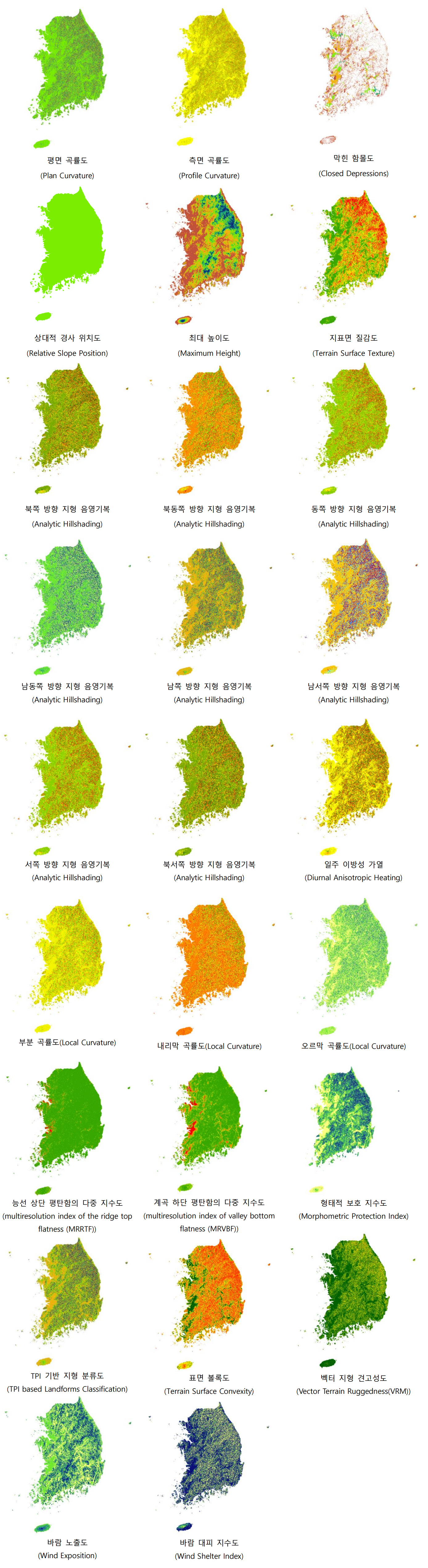

Table 1.Topographic analysis data
Table 2.Hydrologic analysis data
참고문헌
Appendix
Figure & Data
References
Citations
Citations to this article as recorded by 
 PubReader
 ePub Link
 Cite
Cite


Editorial Office of GEO DATA

#816, 8-13, Gwangpyeong-ro 56-gil, Gangnam-gu, 06367 Seoul, South Korea
Tel: +82-2-6677-5682 E-mail: geodata@gaidas.org
Corporate registration number: 780-82-00418