
Articles
- Page Path
- HOME > GEO DATA > Volume 3(4); 2021 > Article
-
Article
Space Science
다목적실용위성 5호 영상을 이용한 이란 일람 지역의 방사왜곡 보정 후방산란계수 데이터 - 양도철*
- Radiometric Distortion Corrected Radar Backscattering Coefficient Data over Ilam, Iran using Kompsat-5 SAR Image
- Dochul Yang*
-
GEO DATA 2021;3(4):28-31.
DOI: https://doi.org/10.22761/DJ2021.3.4.004
Published online: December 31, 2021
한국항공우주연구원 영상체계개발부, 대전 34133, 대한민국
Image Data System Development Division, Korea Aerospace Research Institute, Daejeon 34133, Republic of Korea
- *Corresponding author: dcyang@kari.re.kr
• Received: December 13, 2021 • Revised: December 21, 2021 • Accepted: December 27, 2021
Copyright © 2021 GeoAI Data Society
This is an Open Access article distributed under the terms of the Creative Commons Attribution Non-Commercial License (http://creativecommons.org/licenses/by-nc/3.0/) which permits unrestricted non-commercial use, distribution, and reproduction in any medium, provided the original work is properly cited.
- 268 Views
- 6 Download
요약문
- 다목적실용위성 5호(KOMPSAT-5, K5)를 이용하여 이란의 일람 지역에 대한 기하왜곡에 의한 방사왜곡을 보정한 후방산란계수(Flattening Gamma Naught)를 산출하였다. Flattening 감마 놋은 Analysis Ready Data (ARD)의 Synthetic Aperture Radar (SAR) 핵심 관측치일 뿐 아니라 산림 지역을 포함하여 지형의 높이 변화가 있는 지역에서 지표면 특성만을 반영한 후방산란값을 제공하기 때문에 해당지역의 SAR 밝기 값을 이용하는 활용분야에 기초가 되는 자료이다. Flattening 감마 놋 데이터는 K5 SAR 영상의 해상도와 동일하게 제공되어 이란 일람 지역의 데이터는 K5 광역 모드의 공간적인 해상도인 20 m로 제공된다. Flattening 감마 놋을 생성하기 위해서 30 m 해상도의 SRTM (Shuttle Radar Topography Mission) DEM을 오버샘플링해서 사용하였으며 K5 영상에서 제공되는 지역 입사각(GIM layer) 정보를 이용하여 Flattening 감마 놋 생성이 불가능한 섀도우 지역 등을 판별하였다. 산출한 Flattening 감마 놋의 신뢰성을 판단하기 위해 히스토그램 분석과 입사각에 따른 경향성을 조사하였고 이를 타 후방산란계수들과 비교하여 성능의 우수함을 검증하였다. 알고리즘 및 절차에 대한 자세한 내용은 이전 연구 및 참조논문에 제시되어 있다.
Abstract
- Flattening gamma naught was calculated using Korea Multipurpose Satellite 5 (KOMPSAT-5, K5) by correcting the radiometric distortion caused by geometric distortion over Ilam, Iran. The flattening gamma naught is not only the SAR core observation of Analysis Ready Data (ARD), which is utilized for artificial intelligence and big data, but also the basis for all fields of application that use the SAR brightness by providing the backscattering values only from surface characteristics. The flattening gamma naught data is provided with the same resolution as that of the K5 SAR image, so the data over the Ilam, Iran have the spatial resolution of the K5 Wide Swath mode of 20 m. Shuttle Radar Topography Mission (SRTM) DEM with a resolution of 30 m was oversampled to generate the flattening gamma naught, and shadow areas where flattening gamma naught generation was not possible were identified using GIM layer information provided with the K5 image. In order to determine the reliability of the calculated flattening gamma naught, histogram analysis and tendency according to the incident angle were investigated, and the performance was verified by comparing it with other backscattering coefficients. Details of the algorithm and procedure are presented in previous studies and reference papers.
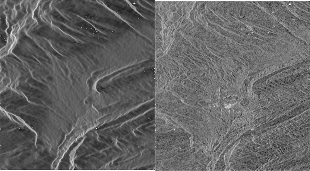
- K5 SAR 영상을 이용하여 이란 일람 지역의 기하왜곡에 의한 방사왜곡을 보정한 후방산란계수, 즉 Flattening 감마 놋 데이터를 산출하였다. 직하 방향대신 측면 방향으로 영상을 관측하는 SAR 고유의 특성으로 SAR 영상은 산악지역 같은 지형의 높낮이가 변하는 지역에서 기하왜곡에서 기인한 방사왜곡이 발생한다. Flattening 감마 놋은 이러한 방사왜곡을 보정하여 지표면 고유의 산란특성에 따른 후방산란값을 제공하여 인공위성 영상 데이터를 이용한 미래 인공지능 및 빅데이터 활용의 기반이 되는 ARD 데이터의 SAR 핵심 관측치로 사용될 예정이고 산불 탐지, 눈 덮임 파악, 빙하관측, 변화탐지, 영상 정합(Co-registration) 및 병합(Mosaicking) 등 영상 밝기 값을 이용하는 다양한 활용분야에 기초 자료로 사용될 수 있다(Small, 2011; Yang, 2020). 본 이란 일람 지역의 Flattening 감마 놋 데이터의 해상도는 K5 광역모드 영상의 해상도와 동일한 20 m이며 SAR 영상 관측 좌표계로 제공된다. 제공된 관측 영역의 공간적 범위는 위도 33.66 ° N ~ 33.75 ° N, 경도 46.16 ° E~46.26 ° E이며 제공되는 샘플 영상을 Fig. 1에 보여주고 있다.
1. 서론
- SAR의 기하왜곡에 의한 방사왜곡을 보상하여 지표면 산란특성에 따른 후방산란값을 제공하기 위해서, 기존의 레이더 시그널의 입사면을 이용하여 정규화 하는 방식 대신 DEM 각각 픽셀의 지리적인 위치와 SAR 영상상의 위치 관계를 정밀히 매핑하고 DEM 픽셀이 감마 평면에 투영되는 실제 영역을 계산하여 그 면적으로 SAR 밝기 값을 정규화 하는 방식을 이용하였다(Small, 2011). K5 SAR 영상을 이용하여 이란 일람 지역의 Flattening 감마 놋 데이터를 생성하기 위해 K5 광역모드 SAR 영상과 SRTM DEM을 사용하였다. K5 광역모드 데이터는 20 m 해상도를 가지고 SRTM DEM은 30 m 지상 표본 거리(GSD)를 가지고 있어 DEM와 SAR 영상의 매핑 함수를 생성하기 위해서 DEM을 오버샘플링하여 DEM의 GSD를 SAR 영상의 샘플링 간격보다 조밀하게 만들어 사용하였다. 또한, K5에서 제공되는 지역 입사각 정보(GIM Layer)를 이용하여 SAR 시그널 값이 존재하지 않는 섀도우 지역 및 오류 픽셀을 프로세싱 과정에서 배제한 후 사용하였다. 산출한 Flattening 감마 놋 데이터 신뢰성을 검증하기 위해 첫째, 히스토그램 분석을 통해 타 후방산란계수값과 비교를 하여 지역 입사각 변화에 의해 발생되는 왜곡현상이 감소되었는지 확인하였고 둘째, 지역 입사각에 따른 후방산란값의 경향성이 존재하지 않음을 확인하였다. 적용한 알고리즘에 대한 검증결과는 Yang (2020)에서 확인 가능하다.
2. 본론
- Fig. 1은 이란 알람 지역에 대한 DEM을 감마 평면으로 투영하여 계산한 감마 면적(Gamma Area)과 감마 면적으로 영상의 밝기 값을 정규화 하여 생성한 Flattening 감마 놋 영상을 보여주고 있다. 감마 면적은 산악 지역에서 레이더 시그널의 입사방향에 위치한 경사면은 크게 나타나고 반대 방향의 경사면은 작게 나타나는 것을 알 수 있다. 감마 면적으로 정규화 하여 계산한 Flattening 감마 놋은 산악지역에서 SAR 관측 기하와 실제 지형과의 차이에서 발생하는 Fore-shortening 및 Layover 등의 기하왜곡에 의한 방사왜곡을 보정하여 레이더 빔의 입사각의 변화나 지형높이의 변화에 의존적이지 않는 지표면 고유의 후방산란특성을 반영하는 것을 알 수 있다.
3. 결과
- 본 이란 일람 지역의 Flattening 감마 놋 데이터는 K5 SAR 영상과 외부 DEM을 이용하여 생성한 방사왜곡을 수정한 후방산란계수값 샘플로 향후 ARD 시스템 개발을 통해 제품형태로 개발하여 제공할 계획이다. 본 Flattening 감마 놋 데이터는 K5 SAR 영상획득 좌표에서 제공되지만 영상제품에 포함되어 제공되는 Rational Polynomial Coefficients (RPC)를 통해서 쉽게 지리정보 좌표계로 변환이 가능하다.
4. 결론 및 토의
-
Acknowledgements
- 본 연구는 한국항공우주연구원의 위성정보활용사업을 통해 수행되었습니다.
- Small D (2011) Flattening Gamma: Radiometric Terrain Correction for SAR Imagery. IEEE Trans Geosci Remote Sens 49(8):3081–3093Article
- Yang D (2020) Kompsat-5 Flattening Gamma Naught Generation Test. International Symposium on Remote Sensing 2020, BEXCO, Busan, 22-24 Apr 2020
참고문헌
Appendix
Figure & Data
References
Citations
Citations to this article as recorded by 
 PubReader
 ePub Link
 Cite
Cite

Editorial Office of GEO DATA

#816, 8-13, Gwangpyeong-ro 56-gil, Gangnam-gu, 06367 Seoul, South Korea
Tel: +82-2-6677-5682 E-mail: geodata@gaidas.org
Corporate registration number: 780-82-00418